


Great Centenary Brisbane River Walk 2008
- Date and departure details
- Purpose statement
- What to see
- What to bring
- Route details and maps
- RSVP
- Description of Route
DATE
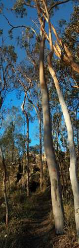
Saturday, 19 July has been scheduled for the second "Great Centenary Brisbane River Walk", a 12km walk along Wolston Creek and Brisbane River bushland reserves in the Centenary suburbs. First held in September 2006, this year's Great Walk is being held in conjunction with the Peaks to Points Festival.
- START: Tomkins Rd, Riverhills - meet at 7:45am for briefing prior to departure at 8:00am sharp. (Meet at the park gate at southern end of Tomkins Rd.)
- FINISH: Bus stop at Jindalee Primary School, Burrendah Rd, Jindalee. ETA between 1pm amd 2pm. Return to vehicles via 450 bus service.
PURPOSE
To celebrate the past victories in gaining increased bushland reserves and parks, including public access to and along our river and creeks, in the Centenary Suburbs. There have been some hard yards over the years in reaching this point, and as bushcarers (if not campaigners!) we are still hard at it.
Now, we and the whole community deserve to share and make good use of these assets. This map shows the 250ha of bushland and parks in Centenary Suburbs which have been won through community action in the last 15 years.
- Observe various features and historical connections along the way;
- See the contrasting riparian landscapes and ever-changing vistas, even in this relatively short length, as we move from one reach to the next;
- Some challenges that remain - weed infestations, encroachments and other mistreatment of our natural heritage in this area.
WHAT TO BRING:
Essential:
|
Provisions:
Optional:
|
ROUTE DETAILS and MAPS
Grading of the walk is generally easy to medium. A few short sections are slippery and will require caution. Given the length, be aware of the need for reasonable fitness.
Public toilets are located at the end of Sumners Rd and at Westlake Drive near Mt Ommaney Creek.
Route length
The route length is estimated to be between 12 and 13 km. Starting at 8am, the estimated arrival time at Jindalee Primary School is between 1pm and 2pm. This is based on an easy amble, and rest breaks at intervals to view the various bushcare work areas and other features along the way.
Maps
- Map set - scales 1:25,000 & 1:10,000 (4 sheets, 960KB PDF)
- Tabular route description with distances along each section
- Coucal Trail, Pullen Reach - scale 1:5000
- Mt Ommaney Walkway - scale 1:5000
RSVPs needed for all participants. Please RSVP by email or phone Ed at 3376 1389.
Some people may choose to walk only part of the whole route - that's fine but again let us know beforehand so we can advise you of likely timings of passing particular points.
- Start at Tomkins Road at 8am sharp, leaving vehicles at this point (in Tomkins Road) or otherwise organising car shuffle;
- west along the Wolston Creek park lower path, downstream towards the river - home of Wolston Creek Bushland Group;
- along Riverpoint Boulevard, Rivervista St to the park at the end of Sumners Road;
- north to Popes Reach, then to Derwent Place and Curlew Place, observing Popes Reach bushland reserve;
- across park to Daintree Place, then upstream along west side of gully to Sumner Rd bus terminus;
- back downstream along east side of gully to riverfront at rear of houses on Cascade Close, arriving at Westlake Drive;
- short detour to view the pocket of riparian bushland in the gully at bottom end of the Juba St park;
- from Westlake Drive dead end to Riverview Close and Balaton St;
- walk full length of Coucal Trail, along Pullen Reach bushland reserve from Balaton St to Fig Tree at Tennent St - home of Westlake-Riverhills Bushcare Group;
- Tennent St to Wendouree Crescent via riverfront park;
- by road along Wendouree Crescent and Westlake Drive to Carnegie St;
- walk the public riverfront land at rear of Carnegie St properties;
- walk full length of Mt Ommaney Walkway from Westlake Drive to Mt Ommaney Drive - home of Jindalee Bushcare Group;
- along Mt Ommaney Drive to the Jindalee boat ramp park;
- continue along Mt Ommaney Drive to the Jindalee Park;
- back along Burrendah Road to the bus stop outside Jindalee Primary School;
- catch a 450 bus back to stop in Sumners Road nearest to Tomkins Road (at MacFarlane St) (or car shuffle at your own choice and arrangements).
Refer to the Saturday Route 450 bus timetable and route map (342KB PDF).
Return to SORB's P2P Festival activity listing.
PO Box 155, Mount OMMANEY Qld 4074 Australia