| Flinders Peak to Bay Islands Corridor Coalition | Flinders
Peak to
Bay Islands Corridor |
Update Leaflet
No. 1
31 March 1999
|
|
In
this issue...
Related links...
Draft City Plan...
|
|
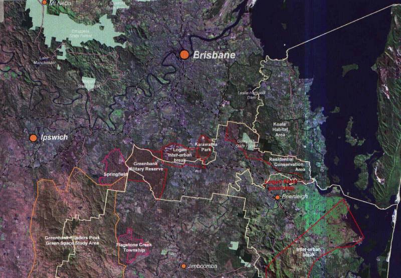
Introduction: RFGM REGIONAL LANDSCAPE STRATEGY and the FLINDERS PEAK TO BAY ISLANDS CORRIDOR This is an update of recent action by members of various Brisbane southside
environmental groups seeking to highlight the importance of what has been
tentatively dubbed (by those groups) the Flinders Peak to Bay Islands
Corridor (FPBIC). This action seeks to draw attention to the
strategic significance of retaining strong bushland linkages in the afore-mentioned
corridor, which includes the Karawatha - Greenbank Corridor. An opportunity
exists to advocate strongly for the FPBIC in the current Regional
Landscape Strategy processes under the RFGM '98 (Regional Framework
for Growth Management). The current BCC Draft City Plan public
exhibition process is also relevant for the Brisbane City component of
the corridor.
The RFGM processes arose out of the SEQ 2001 regional planning processes for SE Queensland and seeks to provide a strategic framework for issues of growth management for the region. The RFGM '98 document identifies a wide range of strategies, Regional Outline Plans (ROP's) and the Govt lead agencies responsible for actions required. The structures for administering these include Regional Organisations of Councils (ROC's), ie. groups of Local Govt Councils in the various geographic sectors (WesROC, SouthROC, NorsROC, etc.), including the totality under SEQROC. For details of SEQ 2001 RFGM, refer link: http://projects.dcilgp.qld.gov.au/seq2001/ Included within the Regional Outline Plan (ROP) of the RFGM '98 is the Regional Landscape Strategy (RLS), for which the lead agency is Dept of Natural Resources (DNR). The RLS aims to "protect regionally significant open space in SEQ for current and future generations." It is the current incarnation of what was previously the ROSS (Regional Open Space Strategy). Refer links:
DNR Regional Landscape Strategy
Implementation of the RLS is the responsibility of the Regional Landscape
Strategy Advisory Council (RLSAC). Membership of this Ctee is
some 20 people drawn from SEQ region Local Govt Councils (rep from each
of NorsROC, WesROC, SouthROC, BCC); Govt Depts (DNR, DEH, DCILGP, DTSR);
various industry, agricultural, landholder, tourism and recreation groups;
etc. Queensland Conservation Council (QCC) has a representative,
Peter Kuttner. The current Chair of the Committee is Darryl Low Choy
(Griffith University).
The concept of what has been tentatively termed the Flinders Peak to Bay Islands Corridor (FPBIC) was generated by community members across various Brisbane southside community groups including Oxley Creek Environment Group (OCEG), Oxley Creek Catchment Association (OCCA), Karawatha Forest Protection Society (KFPS), Bulimba Creek Catchment Coordinating Ctee, Brisbane Region Environment Council (BREC), Southern Regional Alliance and Wildlife Protection Society of Queensland (East Logan Branch).
ACTION FOR YOU
.. You support the concept but you seek no further involvement or info
updates;
Prepared by
Ed Parker
Interim Coordinator
|
| Save
Our Riverfront Bushland (SORB) is a Centenary Suburbs
residents' committee established as a result of a public meeting on 1 Sep
1991 held to express concern at the clearing of large tracts of remnant
riverfront bushland.
SORB embraces the joint goals of:
|
SORB
formed the Westlake-Riverhills Bushcare Group (WRBG),
a community group operating under BCC's Bushland Care Program which supports
coummunity bushland rehabilitation activities in Brisbane. Established
since 1993, WRBG's focus at present is the bushland remnant on the eastern
flank of Pullen Reach of the Brisbane River.
Convenor: Maree Norris (3376 6906)
|
|
|
|
|